 ▼
▼

March 18, 2020
Deadly tornadoes ripped through central Tennessee during the early morning hours of March 3, 2020, causing severe damage to homes, businesses, and property. An estimated 116 roads were closed immediately after the storm, and the local utility, Nashville Electric Services (NES), was challenged with quickly identifying damaged assets and repairing distribution lines to restore power.
Preformed Line Products (PLP), under a contract with NES, was contacted early in the morning by a utility representative. Within 48 hours, PLP’s Inspection Services group mobilized two crews and equipment to the Nashville region to start providing aerial coverage with a focus on harder-to-access areas. Each inspection crew included a PLP field engineer and Part 107 certified pilot operating a Matrice 210 drone with a 30x optical zoom camera.
To assist with organizing the inspection workflow and reporting the location of damaged assets, PLP’s GIS analyst launched a PLP storm response dashboard. The dashboard displayed the path of the tornado along with the utility’s distribution pole locations so that PLP field engineers could identify and mark damaged poles on a mobile device. The web-based dashboard displays the inspection results real-time and communicates the damaged pole locations and hazards immediately to the utility.
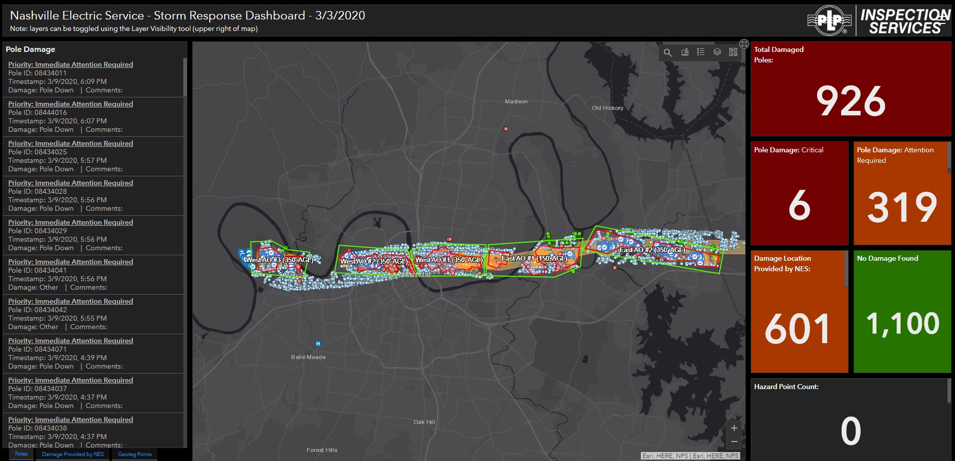
PLP's real-time Storm Response Dashboard
During the inspection, PLP was granted to fly Beyond Visual Line of Site (BVLOS) from the FAA. The process began with a PLP and utility representative identifying and requesting specific drone coverage areas on a map. The waiver was granted, and the FAA allowed the West and East AO #1 regions on the map. The FAA issued a Temporary Flight Restriction (TFR) that prevented all manned aircraft from conflicting with PLP’s drone operations in the designated areas and altitudes over a specified time.
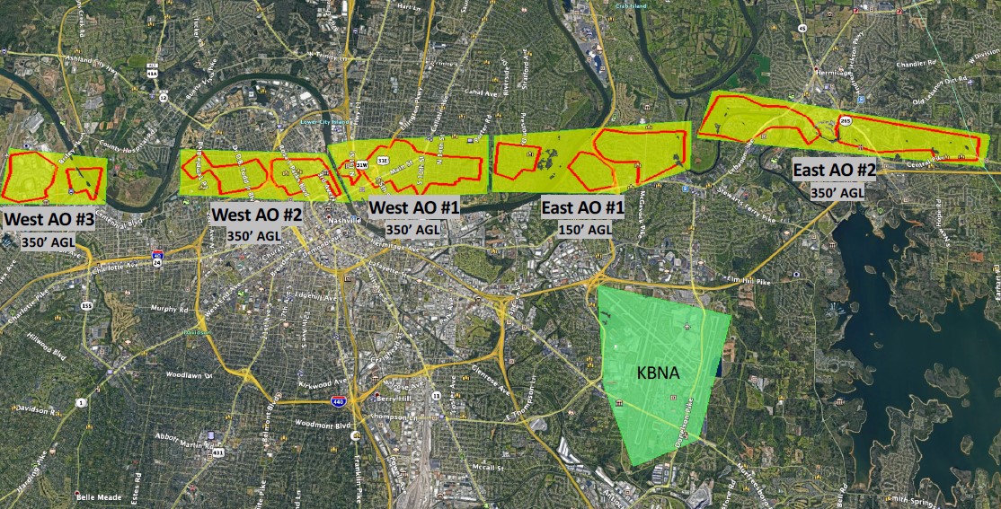
Map overlay highlighting PLP's BVLOS operations
The BVLOS authorization allowed PLP crews and pilots to operate drones up to 1.5 nautical miles from the operator. Since roads were blocked and areas were difficult to access, BVLOS flights proved to be a faster and more efficient way to identify the condition of the poles and surrounding areas.
The final count resulted in over 900 utility poles damaged by the storm. In a few days, the PLP crews identified over 300 damaged poles in the harder-to-access areas and confirmed back to the utility that an additional 1,100 poles remained upright with no major visible damage after the storm.
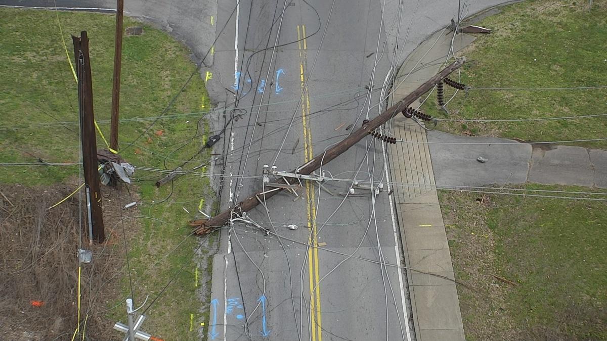
Utility infrastructure damage is located and captured by a PLP Inspection Services drone
Written by:
John Markiewicz, Global Market Manager, Business Development